
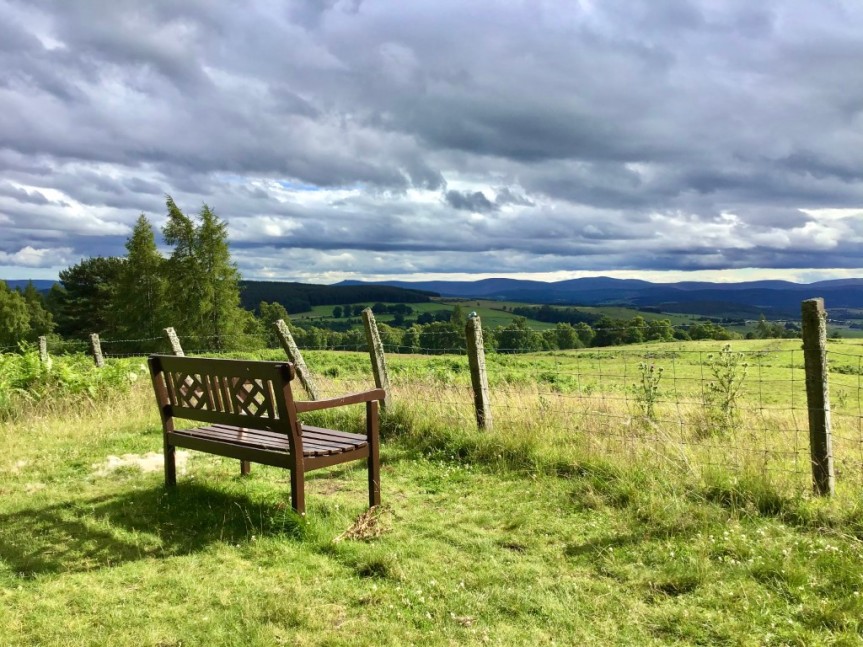
Route Summary This is a short, easy walk with a modest overall ascent of 99 m. There are pleasing rural views throughout, and a good view over mid-Deeside towards distant mountains in the west from the viewpoint and bench at the mid-point on the route, overlooking the village of Lumphanan.
Duration: 1.5 hours.
Route Overview
Duration: 1.5 hours. Transport/Parking: The Stagecoach 202 service from Banchory stops at Lumphanan. Check Timetables. Free public parking in Station Square at the walk start/end point.
Length: 3.790 km / 2.37 mi
Height Gain: 99 meter.
Height Loss: 99 meter.
Max Height: 267 meter.
Min Height: 171 meter.
Surface: Moderate. Mostly on fairly good paths or farm tracks.
Difficulty: Easy.
Child Friendly: Yes, if children are used to walks of this distance and overall ascent.
Dog Friendly: Keep dogs on lead near to farm animals.
Refreshments: We can recommend the Meet Again Tea Shop on Perkhill Road. The Macbeth Arms (limited day-time hours).
Description This gentle little ramble around the rural outskirts of Lumphanan offers some lovely countryside views. At the mid-point, where a bench overlooks the village, there is a fine view over the rolling Deeside farmland and forests towards Mount Keen, the most easterly “Munro”. On the return leg, the walk follows a section of the Old Military Road that ran from Fochabers to Fettercairn, completed under the direction of General Wade’s deputy, Major William Caulfeild, in 1761. This part of the old road was not incorporated into the modern public roads network and is now a path through mixed woodland, becoming a field and farm access track as it climbs over the shoulder of Glenshalg Hill towards Tullochvenus. After a delightful downhill section in mixed woodland, the route re-enters the village at Glen Road under the imposing Stothert Memorial Chapel. The village of Lumphanan is famously associated with King Macbeth of Scotland (or Alba). The Battle of Lumphanan was fought on 15 August 1057, between Macbeth and the future King Malcolm III. According to traditional sources, Macbeth was killed at Lumphanan, having led his retreating forces north to make a final stand. There is a well close to the village where Macbeth is believed to have taken his last drink in the heat of battle and, nearby, “Macbeth’s Stone” is said to be the stone upon which Macbeth was beheaded before his body was buried under a cairn. Needless to say, there are alternative versions of Macbeth’s eventual death after the battle, with his demise allegedly days later in Scone, and burial on Iona. After the walk, consider visiting the interesting “Peel Ring of Lumphanan”, the site of a 13thC motte, now managed by Historic Environment Scotland. The Lumphanan Paths Group are doing a great job in way-marking and maintaining walking routes in the area. See: https://bit.ly/3nuTz8J
Links:
Photos from walk
Download Route Guide (PDF with illustrated Waypoints)
Download GPX file (GPS Exchange Format)
Access Walk on OutdoorActive
Access Walk on OSMaps
Access Walk on AllTrails
Access Walk on Wikiloc

Walk 118 Lumphanan Happy to confirm the only obstacle on this route today was a single tree which only partly blocked the path so it wasn’t an issue.
LikeLike
Thanks. Much appreciated … 🙂
LikeLike
Thanks. Much appreciated … 🙂
LikeLike